
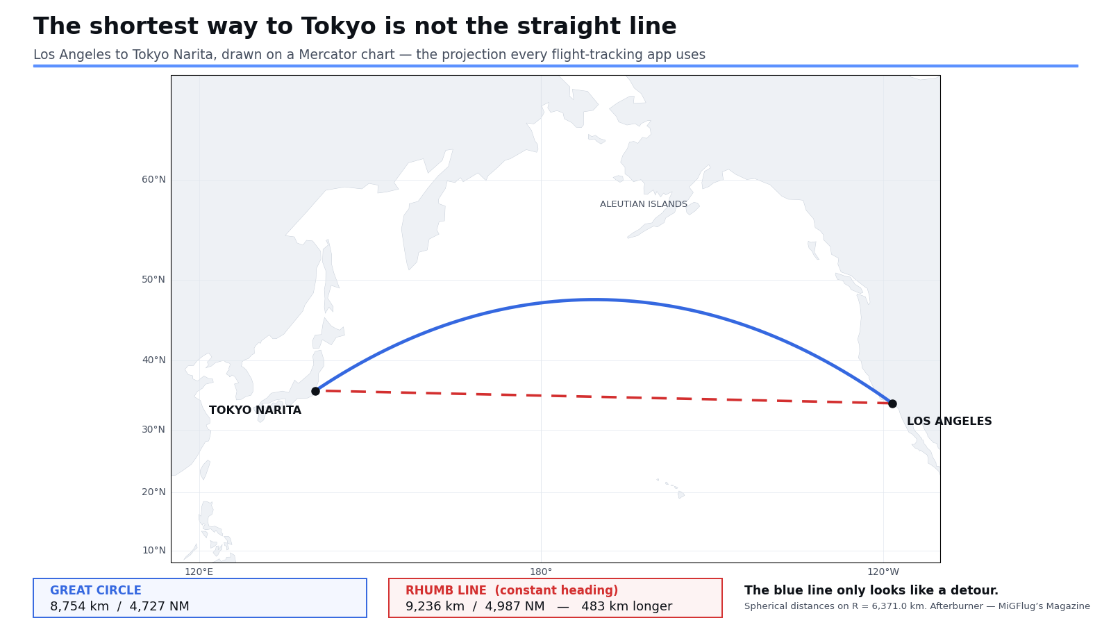
Open a flight tracker halfway through a Los Angeles to Tokyo flight and the aircraft is somewhere it has no business being. Not out in the middle of the blue, where the straight line on the screen says it should be, but up near the top of the map, off the Aleutians, hundreds of miles north of the obvious route.
The internet has a standing explanation for this. Planes avoid the open Pacific, it says, because they want to stay near land, or near diversion airports, or out of the deepest water. It is one of the most searched questions in aviation and almost every part of the popular answer is wrong.
Aircraft do not avoid the Pacific. They cross it in enormous numbers, including on legs with nothing underneath for thousands of miles. What is actually happening is that the shortest path across a sphere looks like a curve when you flatten the sphere onto a rectangle — and every flight tracker in the world flattens it the same way. The map is wrong, not the flight plan.
Quick Facts
Great circle: the shortest path between two points on a sphere — the intersection of the sphere with a plane through its centre
Rhumb line: a constant-heading track; a straight line on a Mercator chart, and longer
Los Angeles to Tokyo Narita: 8,754 km great circle against 9,236 km rhumb line — 483 km of difference
Los Angeles to Sydney: the two differ by about 31 km over 12,000 km, because the leg runs north to south
NOPAC route system: four ATS routes — R220, M523, R580 and A590 — spaced 25 NM apart
Jet stream: NOAA records speeds of more than 275 mph (239 kt / 442 km/h)
North Pacific ETOPS: 207 minutes, an exception granted flight by flight
FAA oceanic airspace: 24.1 million of the 29.4 million square miles it controls
The map is the thing that is lying
The definitive explanation is more than two centuries old and sits in the US government’s own navigation bible. The American Practical Navigator — Bowditch, to every navigator who has ever used it — sets out both kinds of line. A great circle is the intersection of a sphere’s surface with a plane passing through its centre, and it is “the shortest distance along the surface between any two points.” A rhumb line, by contrast, “makes the same angle with all meridians it crosses and appears as a straight line on a Mercator chart.”
That last clause is the whole problem. Mercator was designed in 1569 so that a constant compass heading would plot as a straight line, which is exactly what a sailing ship needed. The price is that it stretches everything toward the poles. Bowditch is unsentimental about the consequence.
And the shape it produces is not arbitrary: “On a Mercator chart, a great circle appears as a sine curve extending equal distances each side of the equator.” The arc you see on the tracker is a sine curve, drawn by the projection.
The test that proves it has nothing to do with the Pacific
If aircraft really were dodging open water, every transpacific flight would bend. They do not, and the exception is the proof.
Los Angeles to Sydney is roughly 12,000 kilometres, almost all of it over the Pacific, with a stretch of empty ocean as forbidding as anything on Earth. Run the numbers and the great circle comes out at 12,061 km while the constant-heading rhumb line comes out at 12,093 km. The difference is about 31 kilometres, a quarter of one per cent. On a tracker that route looks almost perfectly straight.
Los Angeles to Tokyo is a shorter flight over the same ocean, and there the gap is 483 kilometres — more than five per cent. Same ocean, wildly different behaviour. Bowditch explains exactly why, in a single sentence that ought to be better known. The difference between the rhumb line and the great circle increases “(1) as the latitude increases, (2) as the difference of latitude between the two points decreases, and (3) as the difference of longitude increases.”
Los Angeles and Tokyo sit at almost identical latitudes, about 34 and 36 degrees north, separated by a vast span of longitude. That is the worst case — a high-latitude, nearly east-west leg — and it produces a big curve. Los Angeles and Sydney are separated mostly in latitude, running north to south, which is the best case and produces almost none.
The curve is a function of geometry, not geography. The Pacific is incidental. The same effect makes a New York to London track ride up past Newfoundland and Ireland, which is why the North Atlantic looks bent too.
Where the myth keeps a grain of truth
Having demolished the popular answer, honesty requires putting one small piece of it back. Real tracks are not pure great circles either. They are near them, bent by three forces, and none of the three is fear of the ocean.
Wind is the first and the biggest. The Pacific tracks are rebuilt every day. The FAA’s own guidelines for the Pacific Organized Track System are blunt about the driver: “The number of tracks each day will be determined by the position of the jet stream.”
Diversion geometry is the second. Twin-engine rules force planners to keep the route within a defined flying time of a usable airport, and in the Pacific those airports are scarce.
Fixed route structure is the third. Across the top of the Pacific, aircraft do not fly wherever they like. They fly on published roads.
The jet stream, and why the flight home is two hours shorter
NOAA describes jet streams as narrow bands of strong wind typically around 30,000 feet, varying in height between four and eight miles, that “can reach speeds of more than 275 mph (239 kts / 442 km/h).” They are strongest in winter, when the temperature contrast driving them is sharpest, and the American Meteorological Society notes that the subtropical jet “is strongest off the Asian coast” — which is to say, precisely where transpacific flights begin or end.
The effect on a timetable is dramatic, and an airline’s own published schedule shows it better than any explanation. On All Nippon Airways’ summer 2015 schedule, NH5 from Los Angeles to Narita — westbound, punching into the jet — was blocked at 11 hours 50 minutes. NH6, the same route eastbound with the jet behind it, was blocked at 9 hours 45. Two hours and five minutes of difference on an identical great circle, bought and paid for by the wind.
Which is why eastbound and westbound tracks are not the same tracks. Eastbound flights hunt the core; westbound flights run away from it, often several hundred miles off the line an eastbound aircraft would fly on the same day. The daily track message exists to sort this out.
Four roads across the top of the world
Between Alaska and Japan the traffic is heavy enough that free routing does not work. Instead there is the North Pacific route system, NOPAC, and it has recently been rebuilt.
It began in 1974 as five parallel routes spaced at least 50 nautical miles apart, back when standard oceanic separation was 100 NM laterally. Anchorage Center has spent the last few years compressing it. In February 2023 the routes R591 and G344 were deleted. On 25 January 2024 a new westbound route, M523, opened between R220 and R580, available only between FL340 and FL400, and R580 became eastbound only.
The result is four routes — R220, M523, R580 and A590 — on 25 NM spacing using a 23 NM lateral separation standard, pushed up against the northern boundary with Russian airspace. As the ICAO working paper that documents the redesign puts it, the new system “will occupy less airspace than 3 routes previously occupied.” A hundred nautical miles of separation has become twenty-three in fifty years, and the thing that made it possible is navigation precision: RNP 4 and performance-based communication, not better radar. There is no radar out there at all.
A fifth route, N507, is designed and published but not in use. Phase 3 of the redesign is on hold, and the reason is worth knowing: data link reliability. ICAO recorded in 2024 that “issues with data link connectivity have delayed Phase 3 until data link reliability and availability is improved,” and the postponement was still in force at a follow-up meeting in June 2026. When you are separating aircraft by 23 miles over open ocean with no radar, the satellite link is the only thing standing between order and a large problem. One ICAO paper spells out the failure mode: “A network outage can cause closure of a route and descent of many of the aircraft on the routes to reestablish separation.”
Further south, between Japan and North America, the Pacific Organized Track System does the same job differently. PACOTS tracks are not fixed. They are generated daily around the forecast jet stream, published in a track definition message, and thrown away the next day — the Pacific cousin of the North Atlantic Tracks. NOPAC is the motorway; PACOTS is the daily diversion around the weather.
The airports that are not there
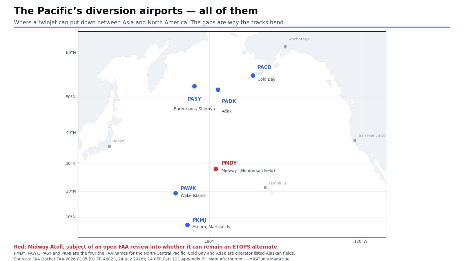
The second force bending the track is the one the myth half-remembers. It is not that pilots want to stay near land. It is that the rules require a twinjet to remain within a certain flying time of an airport where it could actually land, and the North Pacific has very few.
The FAA is candid about how this came about. Advisory Circular 120-42B notes that as twins arrived in long-range flying, “political and funding priorities forced the closure or reduction in basic services of a number of airports, military and civilian, in remote areas that historically had been used as diversion airports for routes over oceanic and/or desolate land areas.” The rules got more permissive and the runways got fewer at the same time.
So the FAA wrote the North Pacific a special number. Standard extended operations approval runs to 180 minutes from an adequate airport. In the North Pacific an operator may stretch that to 207 minutes — but only “on a flight-by-flight basis when an ETOPS Alternate Airport is not available within 180 minutes for reasons such as political or military concerns; volcanic activity; temporary airport conditions; and airport weather below dispatch requirements.” The operator has to name the alternate, consider the air traffic service’s preferred track, and count how many times the authority is used.
The 207 is not a round number by accident. The FAA explains that an earlier policy letter gave “a similar 15 percent increase in the 180-minute maximum diversion time and gave limited relief to ETOPS certificate holders in the specific case of North Pacific Operations.” One hundred and eighty times 1.15 is 207. The clause about “political or military concerns” was written in 2007; since 2022, with Russian Far East fields effectively off the table for Western carriers, it has been doing real work.
The runway holding up tens of thousands of flights
Which brings us to a coral atoll better known for a battle.
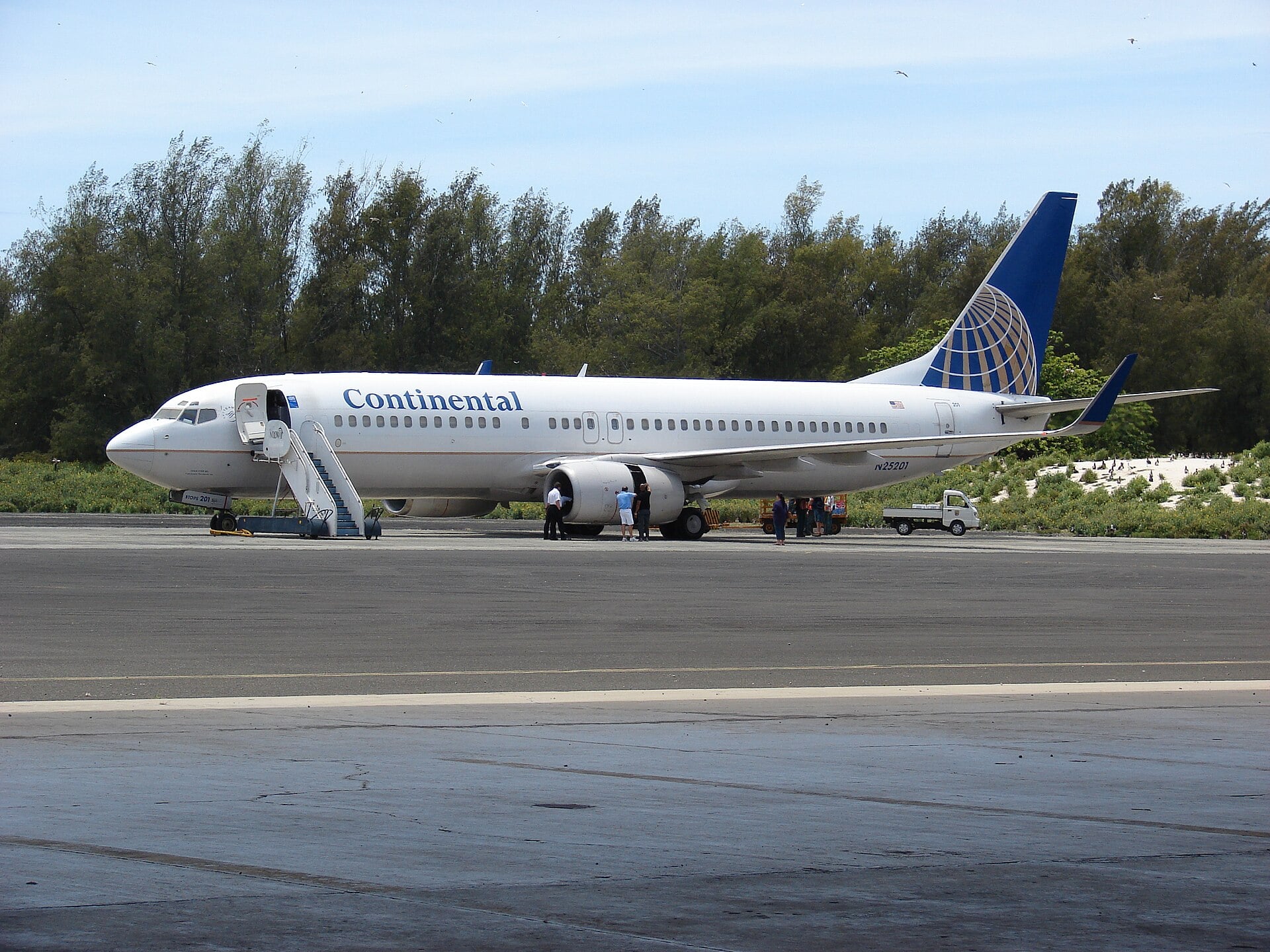
Midway Atoll Airport, Henderson Field, is a Part 139 certificated airport owned by the US government and run by the Fish and Wildlife Service, which took it over from the military in 1996 for wildlife conservation. Almost nothing lands there. Between 2003 and 2021 the FAA counts “at least eleven commercial and military aircraft diversions” in total — fewer than one a year.
And yet, in the FAA’s words, “MDY is currently used in ETOPS flight planning for tens of thousands of trans-Pacific flights annually.” Its value is not that aircraft use it. Its value is that it exists, so that the line on the chart is legal.
That may not last. In July 2026 the FAA opened a public docket on Midway’s future, and the language is not reassuring: the airport’s “infrastructure is deteriorating and will require significant financial investments and rehabilitation within the next three to five years to maintain its operational capability.” The runway “is expected to reach a severe level of deterioration within the next five years,” and rehabilitation “exceeds $100 million” against combined annual funding of about $5.1 million. Comments closed on 8 September 2026.
The FAA named the alternatives in the same notice: Wake Island Airfield, Eareckson Air Station on Shemya, and Marshall Islands International at Majuro. Two of the three are military. Lose Midway and the geometry of the central Pacific changes for everyone — not because aircraft would have nowhere to go, but because the legal envelope they must stay inside would shrink.
And the South Atlantic? The same question, a different answer
The Pacific question has a sibling: why do planes avoid the South Atlantic? It gets asked for the same reason and deserves a more careful answer, because here one popular explanation is a genuine, documented myth — and it has now been tested.
The story goes that the South Atlantic Anomaly, a region where the inner Van Allen radiation belt dips closest to Earth, exposes aircraft to dangerous radiation. In 2021 a team from the German Aerospace Center flew an experiment to find out. Mission Atlantic Kiss put instruments aboard an Airbus A350-900 on a Hamburg to Falkland Islands flight, cruising at FL430 straight through the region for more than five hours. The result, published in Scientific Reports in 2023, was unambiguous.
The physics is simple once stated. Even inside the anomaly, the trapped protons turn around at altitudes above 100 kilometres and never reach the atmosphere, and a proton would need something like 550 MeV to punch down to 43,000 feet anyway. The paper even traces the rumour to a single German popular-science article from 2002 that offered no evidence for it.
The FAA’s own radiation guidance inverts the claim entirely: shielding from Earth’s magnetic field “is greatest near the equator and gradually decreases to zero as one goes north or south,” so that polar cosmic radiation levels are “about twice those over the geomagnetic equator at the same altitudes.” If radiation drove routing, aircraft would avoid the poles, not the tropics. They do not avoid either.
What is true is that the deep South Atlantic, south of roughly ten degrees, carries little traffic. The reason is prosaic: hardly anybody needs to fly between southern Africa and southern South America. The tropical Europe to South America corridor above it is busy and formally structured, with ICAO recording a daily average demand of 99 flights in 2018 and more than half of the fleet already using random routing rather than the published airways.
Where the South Atlantic genuinely is difficult is communication and diversion. ASECNA told ICAO that “the South Atlantic is a wide remote oceanic airspace, and currently, there is no capability for providing full VHF coverage.” The islands that could serve as alternates are marginal. And the intertropical convergence zone sits across the corridor throwing up storm cells — the weather that Air France 447 was picking its way around on the night of 31 May 2009, on a flight dispatched, for what it is worth, as a 120-minute extended operation with Natal and Sal as its support aerodromes.
What the curve actually means
So the next time a tracker shows your aircraft arcing north toward Alaska instead of heading straight for Tokyo, the honest reading is this. The great circle is the short way, and the screen is drawing it on a four-hundred-year-old projection built for sailing ships. The wind has nudged the track a few hundred miles one way or the other, because a two-hour saving is worth chasing. And somewhere below, a weathered strip of runway on an atoll nobody lives on is quietly making the whole line legal.
It is not a detour. It is the shortest way there, drawn on the wrong shape of paper.
Sources: NGA Pub. No. 9, The American Practical Navigator (Bowditch), Chapter 24; 14 CFR 121.7 and Part 121 Appendix P via the eCFR; FAA Advisory Circular 120-42B, Extended Operations; FAA International Notice intl_2_23001, North Pacific Route Restructure; ICAO APAC ATM/SG/11 WP/29 and ATM/SG/12 WP/23; FAA Docket FAA-2026-8185, 91 FR 46823, 24 July 2026; FAA Air Traffic by the Numbers FY2024; NOAA JetStream and the AMS Glossary of Meteorology; All Nippon Airways published timetable; Meier et al., Scientific Reports 13:9348 (2023); FAA AC 120-61B; ICAO SAT/24 Final Report; BEA Final Report on flight AF 447. Distances for Los Angeles to Tokyo Narita, Los Angeles to Sydney and their rhumb-line comparisons were computed for this article on a sphere of radius 6,371.0 km using published aerodrome reference points.



0 Comments