

Look at the far end of a runway with an Instrument Landing System and you will find a long row of antennas, plus a glideslope mast beside the touchdown zone. Look at the end of a runway served only by a GPS approach and you may find nothing at all: grass, a fence, perhaps a sign. Yet the pilot flying down to it in cloud can get guidance that, on the best GPS approaches, behaves almost exactly like an ILS and can take the aircraft down to a decision height of 200 feet.
The tools that make this possible go by an alphabet soup of names: RNAV, RNP, LNAV, LNAV/VNAV, LP, LPV and RNP AR. They are not rival systems. They are layers of the same idea, and once you see how they stack up, an approach chart that looks like a code puzzle becomes surprisingly logical.
Kurzinfo
- RNAV: Area navigation: fly any path defined by points in space
- RNP: RNAV plus onboard performance monitoring and alerting; the number is accuracy in nautical miles, met 95% of the time
- US chart title: RNAV (GPS) RWY XX, an RNP APCH procedure in ICAO terms
- Lines of minimums: LNAV (MDA), LNAV/VNAV (DA), LP (MDA), LPV (DA)
- Best LPV minimums: As low as a 200 ft ceiling and 1/2 mile visibility (FAA AC 90-107)
- Needs: WAAS in North America, EGNOS in Europe, or another SBAS, for LP and LPV
- RNP AR: RNP values from 0.1 to 1.0 NM, curved RF legs, special FAA authorisation; charted as RNAV (RNP) RWY XX
RNAV and RNP: the difference is a warning light
RNAV, area navigation, simply means the aircraft can fly any path defined by points in space rather than only towards or away from radio beacons. A GPS receiver or a flight management system does that calculation continuously. RNP, required navigation performance, adds one crucial feature. According to the FAA’s Aeronautical Information Manual (AIM), an RNP system includes onboard performance monitoring and alerting, such as receiver autonomous integrity monitoring (RAIM).
In other words, an RNP system does not just know where it is. It knows how sure it is, and it tells the crew when it can no longer guarantee the required accuracy. The number after the letters is that accuracy in nautical miles, which the aircraft must achieve at least 95 percent of the flight time. RNP 0.3 means staying within three tenths of a mile of the intended path.
That is why the FAA classes the ordinary GPS approach as an RNP approach, even though the US chart is titled “RNAV (GPS) RWY” followed by the runway number. Internationally the same procedure is known as an RNP APCH. One chart then offers several lines of minimums, and which one a crew may use depends on what is in the panel.
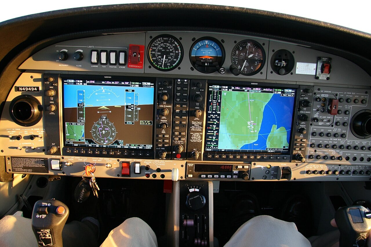
Four lines of minimums on one chart
LNAV, lateral navigation, is the basic GPS approach. It gives left-right guidance only, so it is a non-precision approach flown down to a minimum descent altitude (MDA), where the pilot levels off and looks for the runway.
LNAV/VNAV adds a computed descent path, usually from an approach-approved barometric VNAV system or from WAAS. Because it provides vertical guidance it is flown to a decision altitude (DA), but its integrity limits are wider than those of an ILS or LPV, so its minimums are usually higher.
LP, localizer performance, uses WAAS accuracy to give a tighter, localizer-like lateral course but no approved vertical guidance, so it too ends at an MDA. The AIM says LP is only published where terrain, obstructions or some other reason prevent a vertically guided procedure. It is not a fail-down mode for LPV.
LPV, localizer performance with vertical guidance, is the top of the ladder. FAA Advisory Circular 90-107 describes it as an RNAV function requiring WAAS that provides lateral and approved vertical navigation down to minimums as low as a 200-foot ceiling and half a mile of visibility, the same as a typical Category I ILS.
There is a technical footnote that matters. LPV and LNAV/VNAV are classed as approaches with vertical guidance (APV), not precision approaches, because they are not required to meet the precision approach standards of ICAO Annex 10. For the pilot, though, an LPV feels like an ILS: a needle for the centreline, a needle for the glidepath, and a decision altitude at the bottom.
Duncan Aviation explains what an LPV approach is and what WAAS adds to plain GPS.
WAAS and EGNOS: fixing GPS from the ground up
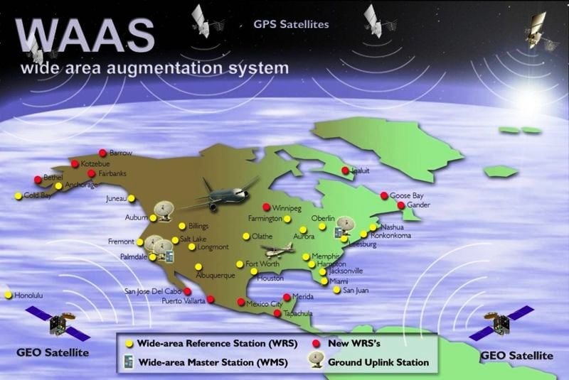
Plain GPS is not accurate or trustworthy enough on its own to guide an aircraft to 200 feet. The fix is a satellite-based augmentation system, or SBAS. In North America it is the FAA’s Wide Area Augmentation System. Its reference stations sit at precisely surveyed sites, so any error in the GPS signals they receive can be measured.
The FAA explains that the reference stations pass their data to WAAS master stations, which generate a correction message every second. Uplink stations send the messages to navigation payloads on geostationary communications satellites, which broadcast them on a GPS-like signal. A WAAS receiver applies the corrections and, according to the FAA, can achieve position accuracy of a few metres.
Accuracy is only half of the job. The other half is integrity: knowing instantly when the system is wrong. The FAA says WAAS was designed so that users are notified within six seconds of any hazardously misleading information that would cause an error in the receiver’s position.
Europe has its own SBAS, the European Geostationary Navigation Overlay Service (EGNOS), developed by the European Space Agency and Eurocontrol for the European Commission. It was certified for safety-of-life use in 2011 and supports LPV approaches at airports across Europe. Japan’s MSAS and India’s GAGAN do the same job in their regions. Without one of these services overhead, there is no LPV.
Sporty’s Pilot Shop walks through flying an LPV GPS approach on a Garmin GTN 650 navigator.
RNP AR: curved approaches into mountains
At the far end of the scale sits RNP AR, authorisation required. These procedures can use RNP values as low as 0.1 nautical miles and curved radius-to-fix (RF) legs, letting an aircraft follow a precise, bending path through valleys or around noise-sensitive areas where a straight-in ILS beam would hit terrain. In the US they are titled “RNAV (RNP) RWY” followed by the runway number, and every chart says “Authorization Required”.
The AIM spells out the price of admission. Every operator needs specific FAA authorisation through operations specifications or a letter of authorisation, with no exceptions, and the aircraft and crews must meet strict equipment and training standards set out in Advisory Circular 90-101.
Alaska Airlines helped pioneer the concept in the 1990s for its flights into Juneau, where the approach threads between mountains and the weather is often poor. In an Alaska Airlines feature, Captain Bret P., the airline’s managing director of network operations control, called RNP “a game-changer”.
Why ILS is not going away yet
Satellite approaches are cheap to add, because the hardware sits in orbit and in the aircraft rather than at every runway end. But they depend on faint signals from space, and GPS jamming and spoofing have become a daily problem in parts of the world. That is why regulators such as EASA advise keeping a ground-based backup, and why Switzerland paused its plan to switch off the Instrument Landing System at Bern in 2026.
AviationWeek on RNP procedures at Queenstown, New Zealand, where the approach weaves through mountainous terrain.
For now, the two coexist. The ILS remains the workhorse for low-visibility airline operations, while LPV has brought ILS-like approaches to many small airports that could never justify a localizer and a glideslope. Next time you see “RNAV (GPS)” on a chart, read down the minimums: the line you can use tells you exactly what your aircraft knows about where it is.
Sources: FAA Aeronautical Information Manual (chapter 1 section 2; chapter 5 section 4), FAA Advisory Circular 90-107, FAA Satellite Navigation: WAAS How It Works, Alaska Airlines newsroom, FAA Satellite Navigation: GPS/WAAS Approaches
Header photo: Quintin Soloviev / Wikimedia Commons, CC BY 4.0


0 Comments