
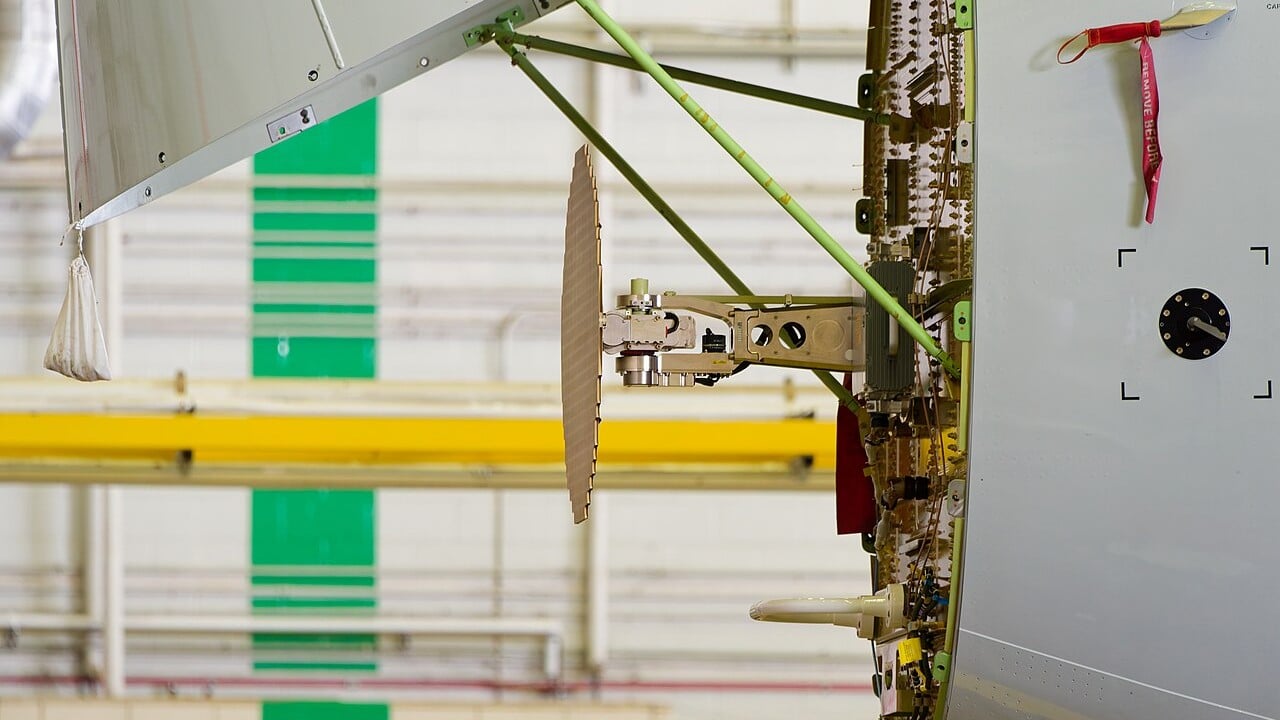
Behind the painted nose cone of almost every airliner sits a flat disc about the size of a dustbin lid, nodding up and down and sweeping left and right, all flight long. It is the weather radar, and on a summer night over the Alps or the Gulf of Mexico it is the pilots’ best view of the thunderstorms ahead.
Most passengers assume it shows clouds. It does not. It cannot see clouds, it cannot see turbulence in clear air, and if the pilots set it up badly it can look straight over the top of a storm that would wreck the aeroplane. Understanding why is the whole art of using it.
Here is how airborne weather radar actually works, what the green, yellow, red and magenta on the screen mean, and how crews use it to thread a path around the worst weather on Earth.
Informations clés
- Qu'est-ce que c'est : A forward-looking pulse-Doppler radar, usually in the nose, that shows precipitation ahead
- Band: X-band, roughly 8 to 12.5 GHz, a wavelength of about 3 cm
- What it sees: Liquid precipitation and wet hail; not cloud droplets, not clear-air turbulence
- Colours: Green light, yellow moderate, red heavy, magenta extreme
- Key controls: Tilt (beam angle) and gain (receiver sensitivity)
- Avoidance rule: At least 20 miles from severe storms or intense echoes (FAA AIM)
- Windshear: First predictive windshear radar certified on 1 September 1994 (Bendix RDR-4B)
A torch in the nose
The radar works like a torch in a dark room. The antenna fires short pulses of microwave energy forward through the radome, the nose cone made of material that radio waves pass straight through. When a pulse hits raindrops, a tiny fraction bounces back. The time it takes to return gives the range; the direction the antenna was pointing gives the bearing.
Airliner weather radars work in the X-band, at roughly 8 to 12.5 GHz, a wavelength of about 3 cm. That is a compromise. Ground radars like the US NEXRAD network use 10 cm waves that punch through heavy rain, but they need huge dishes. A 3 cm wave lets a useful beam come from an antenna small enough to fit inside a nose cone.
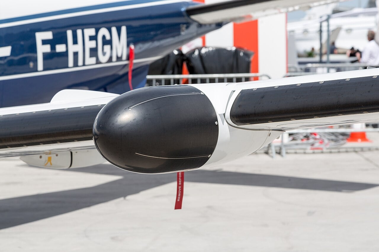
The antenna is stabilised. It is linked to the aircraft’s attitude reference, so it keeps scanning relative to the horizon even while the aeroplane pitches and rolls. Not every radar lives in the nose, either: on single-engine turboprops like the Daher TBM, the radar sits in a pod under the wing because the propeller occupies the nose.
Why it sees rain, not clouds
Here is the first “aha”. The strength of a radar echo rises with the sixth power of the droplet’s diameter. Double the size of a raindrop and it reflects 64 times more energy. Cloud droplets are so tiny that at X-band they barely register. The radar is not a cloud detector at all; it is a rain detector.
The second “aha” is that water matters as much as size. Wet hail and big raindrops are brilliant reflectors. Ice is not. Honeywell’s radar specialists point out that the frozen upper part of a thunderstorm can be lifting moisture above 37,000 feet and still paint only a light green, because there is little liquid water up there to bounce the beam back.
So the colours on the display are a measure of how much liquid water the beam hits. Green means light precipitation, yellow moderate, red heavy, and magenta extreme. Pilots and controllers speak of these as rising levels of threat, because heavy rain usually marks the violent core of a convective storm. Usually.
Collins Aerospace introduces MultiScan ThreatTrack, its automatic airliner weather radar.
Tilt: the most misunderstood knob
The beam is a cone a few degrees wide, and the Earth curves away beneath it. Honeywell calculates that at 100 nautical miles the surface has dropped about 6,600 feet below a level line, and at 200 nm more than 26,000 feet. Fly at FL250 with the tilt at zero and, 120 nm ahead, the centre of the beam is passing almost 37,000 feet up, over the top of anything but the tallest storm.
That is why the tilt control matters so much. The aim is to point the beam at the wet, reflective lower part of the storm, below the freezing level, not at its icy summit. A common technique in cruise is to lower the tilt until ground returns just appear at the outer edge of the display, then watch for storm cells standing out from the clutter. SKYbrary suggests around one degree down in cruise and a quick sanity check: at about 30,000 feet with ten degrees down, the ground should show up at around 30 nm.
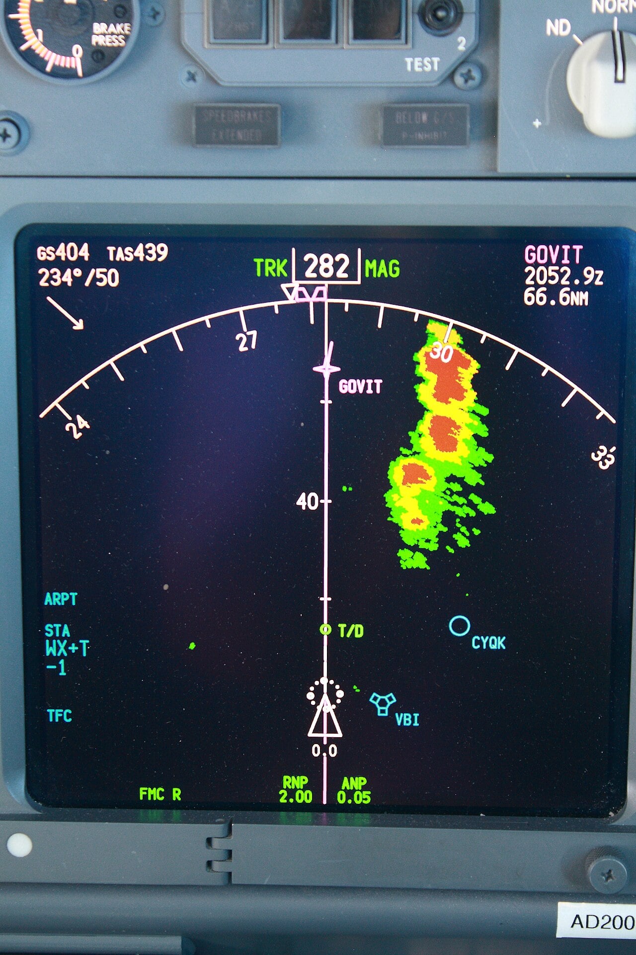
Look closely at that Boeing 737 display, photographed en route to Winnipeg. The line of cells to the right of track shows the classic pattern: green edges, yellow, then red cores. The crew can see it well ahead and plan a turn long before they reach it.
Gain is the other dial. It sets how sensitive the receiver is. Turning it up makes weak echoes look stronger, which can help pick out a storm’s frozen top; turning it down helps find the hardest core inside a big red mass. Modern radars such as Honeywell’s IntuVue RDR-4000 and Collins’ MultiScan do much of this automatically, scanning at several angles and raising gain for the high, icy parts of a cell.
What it cannot see
The FAA puts it bluntly. Weather radar is for avoiding severe weather, not for flying into it, and the display is no guarantee of a smooth ride.
Several traps catch the unwary. A heavy cell can soak up the radar energy entirely, a process called attenuation, leaving a black “shadow” behind it that looks like clear sky but may hide another storm. Hail can fall miles from the cloud that made it. And because the beam spreads with range, a red cell more than 100 nm away may show only green or yellow until the aeroplane gets closer, an effect Honeywell traces to the limits of the radar’s range compensation.
Modern Doppler radars help. By measuring the frequency shift of the returns, they can detect the churning motion of raindrops and flag turbulence inside precipitation at shorter range. Turbulence in dry, clear air remains invisible.
On 9 June 2024, Austrian Airlines flight OS434 from Palma de Mallorca was descending through about FL200 towards Vienna when it flew into hail. The stones shredded most of the A320’s radome and damaged both front windscreens. The crew declared a mayday and landed safely around 20 minutes later; none of the 173 passengers and six crew was hurt.
Predictive windshear
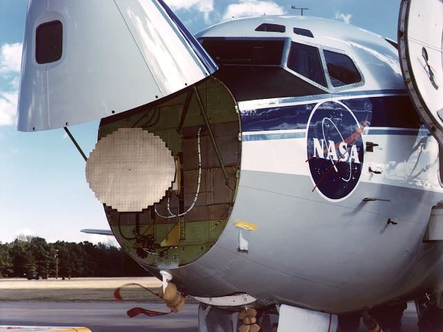
The radar earned a second job after a run of microburst accidents in the 1970s and 1980s, culminating in the loss of Delta Air Lines Flight 191 at Dallas/Fort Worth in 1985. In 1986 NASA and the FAA launched a joint airborne windshear programme, and NASA Langley spent two years flight-testing forward-looking sensors, including a modified Collins X-band radar in the nose of its Boeing 737 research aircraft.
The trick is Doppler. A microburst is a column of cold air slamming into the ground and spreading out, so the radar sees rain moving towards the aircraft on one side and away on the other. On 1 September 1994, the Allied-Signal/Bendix RDR-4B became the first predictive windshear system certified for airline use. Today such radars warn crews of a microburst ahead during take-off and approach, typically with an aural alert, before the aircraft reaches it.
How pilots go around storms
The rules of thumb are old but sound. The FAA’s Aeronautical Information Manual tells pilots to avoid any thunderstorm identified as severe or giving an intense radar echo by at least 20 miles, and to circumnavigate an entire area if it has six-tenths thunderstorm coverage. SKYbrary adds a minimum of 5,000 feet vertically. Between two intense echoes, that means a gap of at least 40 miles before flying through.
Mentour Pilot on the decision every crew faces when a storm sits across the route.
In practice crews ask air traffic control for deviations early, and they stay out from under the anvil, the flat top spreading downwind from the storm, where the FAA warns of severe clear-air turbulence and hail can fall miles from the core. They watch for cells where green, yellow and red are crammed tightly together, a steep gradient that often marks strong shear. And they check behind the obvious cell for the shadow of a second one.
SKYbrary also warns about a trap in tropical storm belts, where a crew dodging cell after cell to one side can end up pointing back the way they came. The fix is to split the work: one pilot on the weather, one on the navigation.
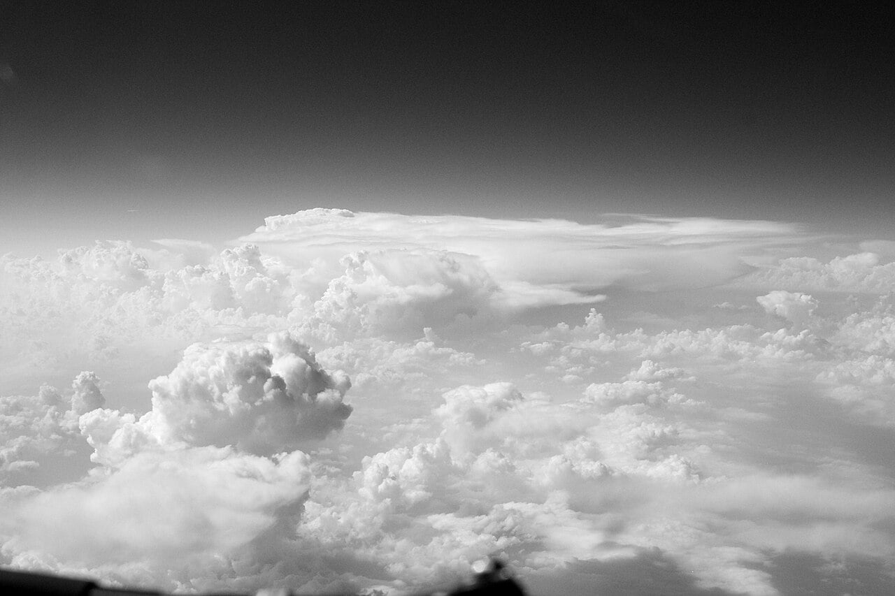
All of it rests on a disc behind a fibreglass nose, listening for echoes of rain. Used well, it lets an airliner slip between storms that tower higher than Everest. Used badly, it shows a calm black screen right up to the moment the hail arrives.
NBAA’s product spotlight on Honeywell’s IntuVue RDR-7000 weather radar.
Sources: FAA Aeronautical Information Manual 7-1-27, FAA Advisory Circular 00-24C, SKYbrary (Airborne Weather Radar; Weather Radar: Storm Avoidance), Honeywell Aerospace, NASA Langley Research Center, NBC News, FOX Weather, Mentour Pilot, Wikipedia (Weather radar; Airborne wind shear detection and alert system)
0 Comments