
Low-level flying
Low-level flying is a highly valued and vital skill for military aircrew, and the Royal Air Force uses several areas of the United Kingdom for low-level flight training. The United Kingdom is split into 18 different low flying areas, or also known as “LFAs”, the LFA’s being numbered 1-19 (Strangely there is no LFA15). The Ministry of Defence MoF website has a map pictures below showing the location of the low fly areas. The Mach Loop is located within LFA7, which covers the whole area of Wales, except for a minor small section in the north-east area of Powys, which is within LFA9.Locations
First of all - I'd like to thank Mark Jayne from MJA Aviation to allow us to embed the great maps below.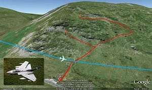
Bwlch viewing area.
 Cad East sits in the shadow of the massive Cadair Idris at the beginning of the Tall-Y-llyn valley. From the top of Cadair Idris it’s possible to view all the way to Snowdon and towards Bala so approaching aircraft can be seen very crisply. There is an access road that runs up through the back of Cad East which does have limited spaces for parking.
Type of images able to shoot - Belly shots, head on, level pass
The height of destination: 420ft
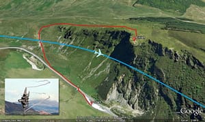
Corris Corner is situated in the south-west end of the Tall-Y-llyn pass, almost above the lake. From here the aircraft have just two options, they can either keep going straight over the lake or turn to a sharp left and follow the valley to Corris offering lovely topside views with the sun behind you, meaning a clear, crisp shot is possible. Take note, this location is fairly tricky in the late afternoons due to the sun being directly in front of you especially during the winter days.
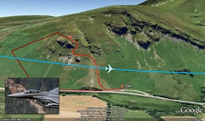
There are a few more locations in Wales, including Heartbreak Hill which is situated in between the Bala and Dolgellau valley, the A5 Pass which flies over Lake Ogwen, and the Dyfi Valley which is a new-ish location northeast of Dinas village. Another location is BlueBell hill which is located just east of the Bwlch.
Type of images able to shoot - Topside
The height of destination: 330ft
Cad East sits in the shadow of the massive Cadair Idris at the beginning of the Tall-Y-llyn valley. From the top of Cadair Idris it’s possible to view all the way to Snowdon and towards Bala so approaching aircraft can be seen very crisply. There is an access road that runs up through the back of Cad East which does have limited spaces for parking.
Type of images able to shoot - Belly shots, head on, level pass
The height of destination: 420ft
Corris Corner is situated in the south-west end of the Tall-Y-llyn pass, almost above the lake. From here the aircraft have just two options, they can either keep going straight over the lake or turn to a sharp left and follow the valley to Corris offering lovely topside views with the sun behind you, meaning a clear, crisp shot is possible. Take note, this location is fairly tricky in the late afternoons due to the sun being directly in front of you especially during the winter days.
There are a few more locations in Wales, including Heartbreak Hill which is situated in between the Bala and Dolgellau valley, the A5 Pass which flies over Lake Ogwen, and the Dyfi Valley which is a new-ish location northeast of Dinas village. Another location is BlueBell hill which is located just east of the Bwlch.
Type of images able to shoot - Topside
The height of destination: 330ft
Bluebell viewing area
- The Art Of Mid Air Selfies
- United States Air Force looking to turn on to Supersonic Mercenaries
- Learn more about the nice work of Mark Jayne on MJA Aviation
Related Questions
What is the Mach Loop?
The Mach Loop is a set of valleys in Snowdonia, Wales, used regularly for military low-altitude flight training, with jets flying as low as 250 feet (76 metres) above the terrain. It lies between Dolgellau in the north and Machynlleth, from which it takes its name, in the south.
Where is the Mach Loop located?
The Mach Loop is in mid-Wales, within the UK's Low Flying Area 7 (LFA7), which covers most of Wales. It sits between the towns of Dolgellau and Machynlleth in Snowdonia. Popular viewing spots such as the Bwlch offer dramatic close-up views of jets threading the valleys.
What aircraft fly the Mach Loop?
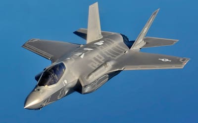
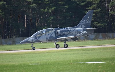
Both the Royal Air Force and the US Air Force use the Mach Loop for low-level training. Aircraft regularly seen there include Tornados, Eurofighter Typhoons, Hawk trainers and US F-15E Strike Eagles, flying fast and low through the Welsh valleys.
Why do military jets fly so low?
Low-level flying is a vital combat skill, letting aircraft use terrain to hide from enemy radar and air defences. It is one of many tactics that have shaped military aviation over the decades, and the RAF practises it across designated UK low-flying areas like the Mach Loop.
How low do jets fly at the Mach Loop?
Jets at the Mach Loop can fly as low as about 250 feet (76 metres) above the nearest terrain, snaking through the valleys at high speed. This makes it one of the best places in the world to watch and photograph fast military aircraft up close.
Why is it called the Mach Loop?
The Mach Loop takes its name from the town of Machynlleth at its southern end, combined with the looping circuit the valleys form. The name has nothing to do with the speed of sound; the jets there fly fast and low but generally below supersonic speeds.
Ridden on my off road bike over that area , have to get back out there now I have finished off-road photography, just need to find out days and times when they are flying
did you get the time when they are flying?
I would like to know which is the period of the year when is possible to see the show
thanks
Timetable for low flying around Mach Loop
https://www.gov.uk/government/publications/operational-low-flying-training-timetable