
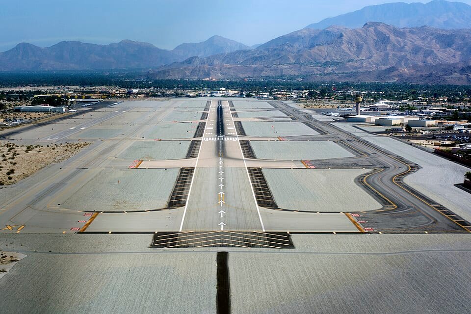
Todas las pistas de los aeropuertos comerciales están pintadas de blanco: franjas, números, rectángulos, flechas y galones que, aunque parecen abstractos desde la ventanilla del pasajero, tienen un significado operativo preciso para los pilotos. Estas marcas no son decorativas. Cada una transmite información específica sobre dónde aterrizar, dónde comienza y termina la pista utilizable y qué tipo de aproximación permite. Interpretarlas mal, o no entenderlas en absoluto, puede significar aterrizar en el lugar equivocado, lo que a su vez puede implicar no tener suficiente pista para detenerse.
El sistema está estandarizado a nivel mundial mediante el Anexo 14 de la OACI y, en Estados Unidos, mediante la Circular Consultiva 150/5340-1 de la FAA. Si bien los pilotos dedican horas a estudiar estas marcas durante su entrenamiento, la mayoría de los pasajeros y aficionados a la aviación desconocen su significado. Esta guía explica todas las marcas principales que verá en una pista, desde los números en el umbral hasta los galones al final de la misma.
Datos rápidos
- Los números de pista indican el rumbo magnético redondeado a los 10 grados más cercanos, dividido por 10.
- Las marcas de la pista son blancas; las marcas de las calles de rodaje son amarillas.
- Existen tres niveles de señalización de pistas: visual, no precisa y precisa.
- Las marcas de umbral indican el ancho de la pista (4 franjas = 60 pies, 16 franjas = 200 pies).
- Los marcadores del punto de mira se encuentran aproximadamente a 1.000 pies del umbral.
Los números: El encabezamiento magnético simplificado.
Los grandes números pintados en cada extremo de la pista son la marca más sencilla y reconocible. Representan la orientación magnética de la pista, redondeada a la decena de grados más cercana y dividida entre diez. Una pista orientada aproximadamente hacia el este con una orientación magnética de 092 grados se denomina Pista 09. El extremo opuesto, orientado hacia el oeste a 272 grados, es la Pista 27. Los dos números en los extremos opuestos siempre difieren exactamente en 18, ya que las dos direcciones están separadas por 180 grados.
En los aeropuertos con pistas paralelas, una letra las distingue: L para izquierda, C para centro y R para derecha, desde la perspectiva del piloto que se aproxima. El Aeropuerto Internacional de Los Ángeles (LAX) tiene cuatro pistas paralelas designadas como 24L, 24R, 25L y 25R; la ligera diferencia de rumbo entre los pares refleja una pequeña divergencia en su alineación.

Marcas de umbral: Donde comienza la pista de aterrizaje
El umbral está marcado por una serie de franjas longitudinales: las gruesas barras blancas que se extienden a lo ancho de la pista. Estas franjas no son arbitrarias. El número de franjas indica el ancho de la pista: cuatro franjas para una pista de 60 pies, ocho para 100 pies, doce para 150 pies y dieciséis para 200 pies. Un piloto que se aproxima a un aeropuerto desconocido puede determinar el ancho de la pista de un vistazo a partir del patrón del umbral, información útil para calcular la altura de aterrizaje y la corrección del viento cruzado.
Justo antes de las líneas de umbral, hay una línea continua que recorre todo el ancho de la pista. Esta línea marca el inicio exacto de la superficie de aterrizaje disponible. Todo lo que se encuentre antes de esta línea, incluidas las plataformas de despegue, no está habilitado para el aterrizaje, aunque pueda parecer pavimento en perfecto estado.

Punto de puntería y zona de aterrizaje
Los dos grandes bloques rectangulares pintados a unos 300 metros del umbral son las marcas de referencia, también llamadas "marcas de 300 metros". (El apodo de "teclas de piano" se refiere en realidad a las marcas de umbral a rayas al inicio de la pista). Es ahí donde el piloto debe apuntar durante una aproximación normal. No hacia el umbral, ni más adelante en la pista, sino hacia estos rectángulos específicos. Aterrizar en el punto de referencia garantiza que la aeronave utilice la pista de manera eficiente, manteniéndose alejada del umbral.
Más allá del punto de referencia, las marcas de la zona de aterrizaje aparecen como pares de barras rectangulares a intervalos de 500 pies. Estas cumplen una doble función: confirman la distancia al umbral durante el rodaje para el aterrizaje y proporcionan una referencia visual en condiciones de visibilidad reducida. En pistas de aterrizaje instrumental de precisión, normalmente hay seis pares de marcas de la zona de aterrizaje, que cubren los primeros 3000 pies de la pista, la zona donde una aproximación correctamente ejecutada debería resultar en el contacto de las ruedas con el suelo.

Umbrales desplazados y galones
En ocasiones, la zona de aterrizaje utilizable no comienza en el inicio físico de la pista. Un umbral desplazado —marcado con flechas blancas que apuntan hacia la dirección de aterrizaje— indica que la parte inicial de la pista está disponible para rodaje, despegue y rodaje, pero no para aterrizaje. Estos desplazamientos suelen deberse a obstáculos en la trayectoria de aproximación, como edificios, terreno o carreteras, que requieren una senda de planeo más pronunciada que los tres grados habituales.
Los chevrones —flechas angulares amarillas o blancas— marcan las áreas más allá del final de la pista que no están disponibles para operaciones aéreas. Estas zonas de seguridad o de frenado pueden parecer parte del pavimento de la pista, pero no están diseñadas para soportar el peso de las aeronaves durante las operaciones normales y están destinadas únicamente a servir como zonas de seguridad. La distinción visual entre los chevrones, los umbrales desplazados y la pista activa es fundamental y se evalúa repetidamente durante la formación de pilotos y las pruebas de vuelo.
Las franjas centrales y de los bordes
La línea central blanca discontinua que recorre toda la longitud de la pista proporciona guía lateral durante el despegue, el aterrizaje y el rodaje. Cada línea discontinua mide 120 pies de largo con una separación de 80 pies, un dato útil para estimar la distancia durante el rodaje. Si un piloto cuenta tres líneas discontinuas que pasan por debajo de la aeronave, habrá recorrido aproximadamente 600 pies.
Las franjas de borde son líneas blancas continuas que marcan los límites laterales del pavimento. En las pistas de aterrizaje instrumental de precisión, estas franjas son obligatorias y proporcionan una guía esencial en condiciones de baja visibilidad. La transición de las franjas blancas de borde (pista) a las marcas amarillas de borde (calle de rodaje) es uno de los límites visuales más claros de cualquier aeropuerto, y cruzar ese límite a velocidad de aterrizaje en lugar de a velocidad de rodaje es precisamente el tipo de error que las marcas de pista están diseñadas para evitar.
Todo el sistema —números, umbrales, puntos de referencia, zonas de aterrizaje, líneas centrales y galones— funciona en conjunto para brindar al piloto información visual continua desde el momento en que la pista se hace visible hasta el rodaje final. Es un lenguaje escrito con pintura, y para los pilotos que lo leen a diario, es tan natural y esencial como cualquier instrumento en la cabina.
Fuentes: Circular consultiva 150/5340-1 de la FAA (Normas para la señalización de aeropuertos), Anexo 14 de la OACI (Aeródromos), Manual del piloto de conocimientos aeronáuticos (FAA-H-8083-25B).
Preguntas relacionadas
¿Qué significan los números en una pista de aterrizaje?
Los números de pista indican la dirección magnética de la pista, redondeada a la decena de grados más cercana y dividida entre diez. Una pista con una dirección magnética de 092 grados se denomina "Pista 09". Los dos números pintados en los extremos opuestos de la misma pista siempre difieren exactamente en 18 grados, ya que las direcciones están separadas por 180 grados.
¿Qué significan las letras L, C y R que aparecen después del número de pista?
En los aeropuertos con pistas paralelas, una letra las distingue desde la perspectiva del piloto que se aproxima: L para izquierda, C para centro y R para derecha. El Aeropuerto Internacional de Los Ángeles, por ejemplo, tiene cuatro pistas paralelas designadas como 24L, 24R, 25L y 25R; la ligera diferencia en la numeración refleja una pequeña divergencia en la alineación.
¿Cómo se puede determinar el ancho de una pista de aterrizaje a partir de sus marcas?
El número de franjas en el umbral indica el ancho de la pista: cuatro franjas para una pista de 60 pies, ocho para 100 pies, doce para 150 pies y dieciséis para 200 pies. Un piloto que se aproxima a un aeródromo desconocido puede calcular el ancho de un vistazo, lo que le ayuda a ajustar la altura de aterrizaje y la corrección del viento cruzado.
¿Cuáles son las "teclas de piano" en una pista de aterrizaje?
Las "teclas de piano" son las llamativas franjas blancas longitudinales pintadas en el umbral de la pista, que marcan el inicio de la superficie de aterrizaje utilizable. A menudo se confunden con los rectángulos de referencia que se encuentran más adelante en la pista, pero el apodo de "teclas de piano" se refiere específicamente a estas marcas de umbral.
¿Cuál es el punto de mira en una pista de aterrizaje?
El punto de referencia son los dos grandes bloques rectangulares pintados a unos 300 metros del umbral de la pista, también llamados "marcadores de 300 metros". Los pilotos apuntan a estos rectángulos en una aproximación normal, en lugar de al umbral o más adelante en la pista, para que la aeronave utilice el pavimento disponible de manera eficiente y se mantenga alejada del umbral.
¿De qué color son las marcas de la pista de aterrizaje?
Las marcas de pista son blancas, mientras que las de calle de rodaje son amarillas. El sistema está estandarizado a nivel mundial mediante el Anexo 14 de la OACI, con especificaciones para Estados Unidos establecidas por la FAA. Existen tres niveles de marcaje de pista: visual, no preciso y preciso, cada uno con mayor nivel de detalle para aproximaciones más exigentes.
¿Qué son las marcas de la zona de aterrizaje en la pista?
Las marcas de la zona de aterrizaje son pares de barras rectangulares colocadas a intervalos de 500 pies más allá del punto de mira. Confirman la distancia del piloto al umbral de la pista durante el rodaje para el aterrizaje y proporcionan una referencia visual en condiciones de visibilidad reducida. Una mala interpretación de las marcas de la pista puede contribuir a errores de aterrizaje, incluyendo: aterrizar en el aeropuerto equivocado.
¿Por qué los pilotos estudian con tanto cuidado las marcas de la pista de aterrizaje?
Porque cada marca transmite información operativa precisa: dónde aterrizar, dónde comienza y termina el pavimento utilizable y qué tipo de aproximación admite una pista. Interpretarlas mal puede significar aterrizar en el lugar equivocado con muy poca pista para detenerse. Dominar estas marcas es parte del camino de un estudiante de piloto hacia su formación como piloto. primer vuelo en solitario.
Publicaciones relacionadas
Los aeropuertos más aterradores para los pilotos
Pilota un avión de combate con MiGFlug
Cómo leer un METAR

0 Comentarios