
| Quick Facts | |
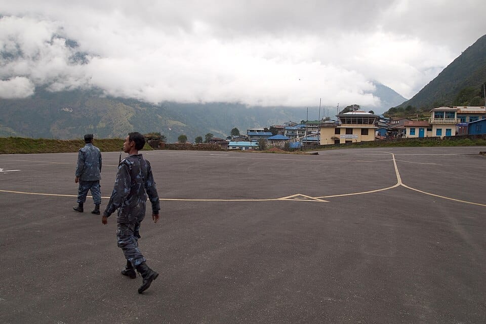
| Lukla (Nepal) | Elevation 9,334 ft; runway 527 m (1,729 ft) with 11.7% gradient; Himalayan cliff at one end |
| Courchevel (France) | Runway 525 m with 18.5% gradient; surrounded by Alpine peaks; no go-arounds possible |
| Paro (Bhutan) | Elevation 7,332 ft; only 8 pilots in the world are certified to land there; visual approach through Himalayan valley |
| Princess Juliana (Sint Maarten) | Jets pass 10–20 metres over Maho Beach on approach; famous for dramatic low approaches over tourists |
| Toncontín (Honduras) | Surrounded by mountains; requires steep turning approach through a valley; now relocated to Palmerola |
| Gibraltar | A public road crosses the active runway; traffic stops for every takeoff and landing |
| Madeira (Portugal) | Runway extended on pillars over the ocean; extreme crosswinds from Atlantic storms |

The runway begins at the edge of a cliff. It ends at the base of a mountain. It is 527 metres long — roughly one-third the length of a standard commercial runway — and it slopes uphill at nearly 12 degrees. There is no missed approach. There is no go-around. You either land on the first attempt at Tenzing-Hillary Airport in Lukla, Nepal, or you don't land at all. This is where the most dangerous approaches in aviation begin.
Not every airport is a flat strip of asphalt in Kansas. Some are carved into mountainsides. Others hang over the ocean on concrete stilts. A few require turns so tight that passengers can see the terminal out of the cockpit window during the approach. At these airports, the margin between routine and catastrophe is measured in metres, seconds, and the skill of the pilot at the controls.
These are the runways that make even experienced pilots earn their pay.
Lukla: The Everest Gateway
Lukla is the front door to Mount Everest. Every trekker, climber, and expedition team heading for the Khumbu Valley starts here, which means Twin Otter pilots make this approach multiple times a day during climbing season. The runway sits at 9,334 feet in a notch between Himalayan ridges. Clouds roll in fast. Wind shear is constant. The approach is visual only — there is no instrument landing system because the terrain makes one impossible.
Pilots aim for the bottom of the runway, which ends at a sheer drop into the valley below. The uphill slope acts as a natural brake — aircraft decelerate as they climb the gradient. On departure, it works in reverse: you roll downhill toward the cliff edge, and if you haven't reached flying speed by the time the pavement runs out, you are going over that edge regardless. Multiple fatal accidents have occurred at Lukla, and it consistently ranks as the world's most dangerous airport.
Courchevel: The Alpine Ski Slope
If Lukla is dangerous because of its location, Courchevel Altiport in the French Alps is dangerous because of its geometry. The runway is 525 metres long — shorter than Lukla — and slopes uphill at an 18.5% gradient. That means the threshold end is nearly 50 metres lower than the far end. Approaching pilots see a wall of tarmac rising in front of them, surrounded on all sides by Alpine peaks.
There is no go-around at Courchevel. The terrain closes in too quickly. If a pilot is not stable on approach, the only option is to divert to Chambéry in the valley below. The airport is certified only for specific aircraft types and requires special pilot qualification. In winter, the runway can be covered in snow and ice, adding one more variable to an approach that already tolerates zero error.
Paro: Eight Pilots on Earth
Paro Airport in Bhutan sits in a deep valley at 7,332 feet, surrounded by peaks that rise to 18,000 feet. The approach requires threading through the valley on a visual path, making multiple turns to align with the runway while mountains loom on both sides. Only a handful of pilots worldwide — reportedly eight — are certified to fly the approach. All commercial flights are operated by Drukair and Bhutan Airlines using specially trained crews.
Flights operate only during daylight and only in clear weather. The approach is not published as a standard instrument procedure because no instrument approach could safely navigate the terrain. Pilots fly it by sight, using landmarks in the valley to judge their position. It is, by any measure, one of the most demanding commercial approaches in the world.
Madeira: On Stilts Over the Atlantic
Madeira's Cristiano Ronaldo International Airport — yes, named after the footballer — had a runway so short that it was extended in 2000 by building a platform over the ocean, supported by 180 concrete columns. The extension hangs above the Atlantic waves like a highway overpass. Crosswinds from Atlantic storms are ferocious, and the airport is famous for producing some of the most dramatic crosswind landing videos on YouTube.
Pilots approaching Madeira must navigate around a mountainous coastline, contend with turbulence generated by the island's terrain, and land on a runway where one end is solid ground and the other is concrete stilts above open water. When the winds exceed limits, aircraft divert to Porto Santo or return to the mainland. On a bad day, the diversion rate is significant.
Every one of these airports is served by regular commercial flights. Passengers board, sit down, and trust that the pilot in the front has done this before — and that the wind, the clouds, and the mountain will cooperate today. At a normal airport, that trust is barely tested. At Lukla, Courchevel, or Paro, it's the only thing between you and a very short runway with no second chances.
Sources: Civil Aviation Authority of Nepal, DGAC France, Drukair, ANA Aeroportos de Portugal
Related Questions
What is the most dangerous airport in the world?
Lukla Airport in Nepal — the gateway to Everest — is widely called the most dangerous commercial runway on Earth. It sits at 9,334 feet, its runway is just 527 metres (1,729 feet) long with a steep 11.7% gradient, and a Himalayan cliff drops away at one end. There is no margin for a missed approach.
Why is Lukla airport so dangerous?
Lukla combines high altitude, a tiny sloping runway and unforgiving terrain. At 9,334 feet the thin air reduces engine and wing performance, the 527-metre strip climbs at 11.7%, and a mountain wall sits at one end while a cliff falls away at the other. Pilots commit to landing with no option to go around.
What makes Courchevel altiport so extreme?
Courchevel in the French Alps has a 525-metre runway with an extraordinary 18.5% gradient — one of the steepest in the world — surrounded by Alpine peaks. The slope is so severe that pilots land uphill and take off downhill, and once committed there are effectively no go-arounds possible, a stark contrast to a normal go-around decision.
How many pilots are certified to land at Paro airport?
Only about eight pilots in the world are certified to land at Paro Airport in Bhutan. Sitting at 7,332 feet and ringed by Himalayan peaks, Paro demands a steep visual approach hand-flown through a valley with no instrument guidance, which is why so few pilots are qualified to fly there.
Why do planes fly so low over Maho Beach?
At Princess Juliana International Airport on Sint Maarten, the runway begins just metres from Maho Beach, so arriving jets pass only 10–20 metres above the sand on final approach. The short distance between the beach and the threshold forces this dramatic low approach, making it one of aviation's most famous plane-spotting spots.
What makes Madeira airport so challenging?
Madeira's runway was extended out over the Atlantic on more than 180 pillars because there was no flat land to build on. The exposed coastal location brings fierce, gusting crosswinds from Atlantic storms, demanding precise handling. Like the discipline of night carrier landings, only well-trained crews make it look routine.
Which airport has a public road crossing the runway?
Gibraltar International Airport has Winston Churchill Avenue, a public road, crossing directly over its active runway. Barriers stop road and pedestrian traffic every time an aircraft takes off or lands, then reopen — a striking arrangement driven by Gibraltar's tiny footprint squeezed between the Rock and the sea.
0 Comments